

A brief history of the mapmaking firm
Over 150 years of cartographic excellence [1]
John Bartholomew & Son Limited was founded in 1826 by John Bartholomew Snr (b 1805), whose father was an engraver for Daniel Lizars of Edinburgh. The third Bartholomew in line, John George Bartholomew (b 1860) - who was a founding member of the Royal Scottish Geographical Society, and appointed Cartographer to King George V - strengthened the company's reputation, bringing about the publication of its own maps, rather than just those of other firms, and initiating layer colouring to indicate relief on medium-scaled maps.
Under the tenure of John (Ian) Bartholomew (b 1890) the company completed its most ambitious projects yet. The magisterial Times Survey Atlas of the World (1922, begun by John G. Bartholomew) took 15 years to prepare and was unrivalled in detail; and the Times Mid-Century Edition (issued in five volumes between 1955 and 1960) contained 122 new maps and a gazetteer of almost 120,000 place names. “The obvious novelty of the new Times Atlas”, wrote a Times journalist in 1955, “may be in the delineation of the new political boundaries created by recent history. But these things, as the 20th century is painfully aware, are the sport of circumstance; the permanent advance is the imparting of knowledge concerning the abiding conformation of land and sea; and it is believed that these maps contain legibility with fullness of information not hitherto approached.
Indeed, by the time the fifth John Bartholomew and his two brothers took over, technology had progressed rapidly, with a more elaborate use of photography and the development of new lithographic techniques allowing for faster and less expensive production. In the late 1960s the Bartholomews brought in a new managing director and a marketing director and a retail sales force of six to cover England, Scotland and Wales, and opened a new warehouse to enable the use of handling machinery such as fork-lift trucks. Map-folding machines were introduced in 1970.
John C. Bartholomew worked hard to assimilate new information as it became available, and The Times Comprehensive Atlas of the World (1967), a reworking of previous Times maps into a single volume, reflected the rapid growth of cities during that period (the rate was 5 to 10 per cent a year) and, for the first time, included maps showing world resources and - two years before the first Apollo Moon landing - sections on space exploration, satellites and “extraterrestrial affairs”. Such was the pace of change at the time, and the popularity of the work, that a new edition was produced the following year. German, Dutch and French editions were also produced. A reduced format, the Times Concise Atlas of the World, appeared in 1972.
Bartholomew also oversaw the evolution of the half-inch to one mile map of Great Britain, which from 1961 to 1974 appeared as Bartholomew's Half-Inch Contoured Great Britain (“Bart's Half-Inch”), and was particularly popular among cyclists. In 1975 Bartholomew enlarged the scale slightly, to 1:100,000, and renamed it the National Series, but with the rise of the car the maps' popularity waned, and they were eventually discontinued.
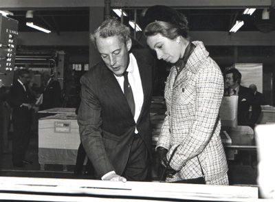
proofs during one of several royal visits to the firm in the 1970's
[1] Abridged & adapted from John C. Bartholomew Obituary (The Times, London - 31 January 2008).
In 1989, John Bartholomew & Son Ltd was sold to the Reader’s Digest Association, ending five generations of family ownership. Reader’s Digest subsequently reorganised the cartographic assets. In the 1990s, parts of the business were sold on to HarperCollins, where they were incorporated into what is now known as Collins Bartholomew. The original firm’s operational records, printing plates, proofs, and business papers were deposited with the National Library of Scotland, forming the Bartholomew Archive, one of the most extensive cartographic archives in public custody.