

John Bartholomew & Son: List of Publications
1. Atlas Publications
As the firm of Bartholomew did not set up its own printing presses until 1860, any atlas production prior to that date was in the form of engraved copper plates made up in page form and produced to the order of the publisher.
These included:
Adam & Charles Black, Edinburgh
Blackie & Son, London, Glasgow, etc.
William Blackwood & Sons, Edinburgh
Cambridge University Press, London
*Cassell & Company, London & New York
William Collins, Sons & Co, Glasgow
T & A Constable, Edinburgh
A Fullarton & Co., London & Edinburgh
*Hodder & Stoughton Ltd, London
W H Lizars Ltd., London
Macmillan & Co., London
Thomas Nelson & Sons, London & Edinburgh
George Newnes Ltd., London
*Oxford University Press, London
George Philip & Son, London & Liverpool
*The Reader’s Digest Association, London, Sydney etc.
*The Times Publishing Co Ltd., London
John Thomson & Co., Edinburgh
John Walker & Co., London
T Ellwood Zell, Philadelphia
* after 1892
(1955, Mid-Century edition)
It was not until Thomas Nelson died in 1892 that Bartholomews produced a catalogue listing their many atlases which were then being published by other publishers.
Progressively after this time, atlases were published under the firm’s own imprint. The major publications from both periods are listed below:
| Year | Publication |
|---|---|
| 1832 | Atlas of Scotland, engraved by W H Lizars and by George Bartholomew (Thomson) |
| 1836 | Lizar’s General Atlas of the World, engraved by W H Lizars and by John Bartholomew Snr (Lizars) |
| 1838 | Blackwood’s County Atlas of Scotland (Blackwood) |
| 1853 | Atlas of Australia with all the gold regions, engraved by S Hall, J Bartholomew and W Hughes (Black) |
| 1856 | Black’s General Atlas of the World, and 1860, 1865, 1884 (Black) |
| 1856 | Black’s Atlas of North America (Black) |
| 1859 | New Atlas of the World (Nelson) |
| 1860 | Royal Illustrated Atlas of Modern Geography, engraved by G H Swanston and by John Bartholomew Jnr (Fullarton) |
| 1860 | Imperial Atlas of Modern Geography (Blackie) |
| 1862 | Black’s New Atlas of Scotland (Black) |
| 1862 | Philip’s Imperial Library Atlas (Philip) |
| 1871 | Descriptive Hand Atlas of the World (Fullarton) |
| 1873 | Handy Atlas of the Counties of England (Philip) |
| 1874 | Handy General Atlas of the World, 1875 and 1885 (Philip) |
| 1879 | Philip’s General Atlas of the World (Philip) |
| 1879 | Handy General Atlas of America (Philip) |
| 1880 | Baddeley’s Guide to the English Lake District—the first maps to use layer colouring (Dulau & Co., London) |
| 1880 | International Atlas & Geography (Collins) |
| 1881 | Zell’s Descriptive Hand Atlas of the World (Zell) |
| 1882 | Handy Atlas of the Counties of Scotland (Philip) |
| 1886 | Pocket Atlas of the World (John Walker); 2nd series of edition to 1901 and 3rd series of editions to 1942 (JB) |
| 1886 | Colonial Pocket Atlas (Walker) 3 editions to 1891 |
| 1887 | Survey Gazetteer of the British Isles (A & C Black); 2nd edition 1904 (George Newnes and JB); 1913—3 editions to 1943 (JB) |
| 1887 | Handy Reference Atlas of the World, 9 editions to 1912 (Walker); 1923—7 editions to 1954 (JB) |
| 1887 | Pocket Atlas of England, 5 editions to 1897 (Walker) |
| 1887 | Pocket Atlas of Scotland, 3 editions to 1893 (Walker) |
| 1887 | Pocket Atlas of Ireland (Walker) |
| 1888 | Pocket Gazetteer of the World (Walker) |
| 1889 | Atlas of Commercial Geography (Cambridge University Press) |
| 1889 | Pocket Atlas & Guide to London, 16 editions to 1920 (Walker); 1922—10 editions to 1956 (JB) |
| 1889 | Pocket Atlas & Guide to Paris, 3 editions to 1898 (Walker) |
| 1890 | Library Reference Atlas of the World (Macmillan) |
| 1890 | Royal Atlas & Gazetteer of Australasia (Thos Nelson) |
| 1890 | Pocket Atlas of Canada, 2 editions to 1897 (Walker) |
| 1890 | Century Atlas & Gazeteer, 12 editions to 1911 (Walker) |
| 1891 | Graphic Atlas (Nelson); 1893, 1910 (Walker); 1932—9 editions to 1956 (JB) |
| 1891 | Popular Hand Atlas of the World (Nelson) |
| 1891 | English Imperial Atlas of the World (Nelson) |
| 1892 | Miniature Atlas & Gazeteer (Nelson); 1894 (Walker) |
| 1892 | Handy Atlas of England & Wales (Black) |
| 1893 | New Hand Atlas of India (Arch Constable) |
| 1893 | Atlas Guide to Europe (Philip) |
| 1895 | Survey Atlas of Scotland, 2nd edition 1912 |
| 1897 | Melrose and Abbotsford Pocket Guide, 4 editions to 1924 |
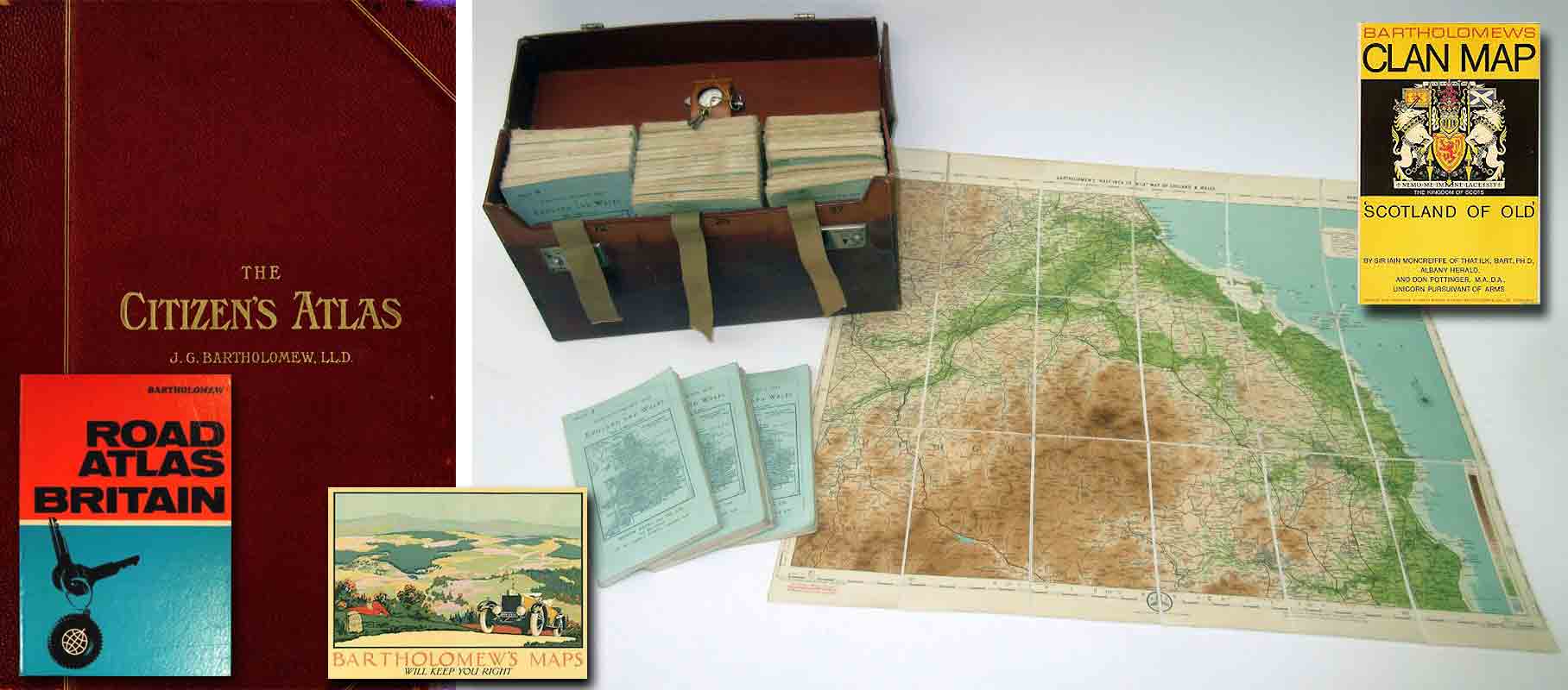
| 1898 | Citizen’s Atlas (Newnes) and 1901; 1912—8 editions to 1952 (JB) |
| 1899 | Atlas of Meteorology |
| 1899 | Royal Atlas of England & Wales (Newnes) |
| 1903 | Pocket Atlas of the British Isles (Newnes) and 1906; 1918—13 editions to 1958 (JB) |
| 1904 | Survey Atlas of England & Wales, 2nd edition 1912 |
| 1904 | Handy Atlas of the British Empire (Newnes) |
| 1906 | Ideal Atlas of the World, 3 editions to 1912 (Walker) |
| 1906 | Climatological Atlas of India |
| 1907 | Handy Reference Atlas of London (Walker); 1913 to 1917; 1921—10 editions to 1968 (JB) |
| 1907 | Atlas of the World’s Commerce (Newnes) |
| 1908 | Imperial Gazetteer Atlas of India, and 1931 (Oxford University Press) |
| 1909 | Cassell’s Atlas of the World (Cassell) |
| 1911 | Atlas of Zoogeography |
| 1914 | International Reference Atlas (Newnes) |
| 1915 | Atlas of the Historical Geography of the Holy Land (Hodder & Stoughton) |
| 1922 | Pocket Atlas and Guide to Glasgow (John Smith, Glasgow) |
| 1922 | Times Survey Atlas of the World (Times) |
| 1923 | Birmingham Pocket Atlas, 9 editions to 1923 |
| 1924 | Universal Hand Atlas (Nelson) |
| 1927 | Manchester Pocket Atlas |
| 1928 | Liverpool & Birkenhead Pocket Atlas, and 1949 |
| 1934 | Newnes Modern World Atlas (Newnes) |
| 1935 | The Times Handy Atlas (Times) |
| 1943 | Compact Atlas of the World, 4 editions to 1957 |
| 1943 | Road Atlas of Great Britain, 22 editions to 1970 |
| 1948 | Regional Atlas of the World |
| 1950 | Edinburgh Atlas Guide, 6 editions to 1974 |
| 1953 | Columbus Atlas of the World |
| 1954 | Edinburgh World Atlas, 10 editions to 1975 |
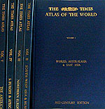
| 1955 | The Times Atlas of the World (Mid-Century edition), in 5 volumes (Times) pub. 1955-60 |
| 1958 | Roadmaster Atlas of Great Britain, 5 editions to 1971 |
| 1961 | Reader’s Digest Great World Atlas, British edition and subsequent special language editions for Australia, Brazil, Canada, Denmark, Finland, France, Germany, Italy, Japan, Mexico, The Netherlands, Norway, Spain, Sweden and USA (Reader’s Digest) |
| 1967 | The Times Atlas of the World (Comprehensive Edition); 5 editions to 1975 (Times); also German editions 1972, 1974 and 1976 |
| 1969 | The Times Moon Atlas (Times) |
| 1970 | Road Atlas Britain, 7 editions to 1976 |
| 1970 | Road Atlas Europe, 4 editions to 1974 |
| 1972 | The Times Concise Atlas of the World; 5 editions to 1975; also Dutch editions 1973 and 1975; and German edition 1976 (Times) |
| 1973 | Town Plan Atlas |
| 1973 | Motorway Atlas, 2 editions to 1975 |
| 1974 | The Times Atlas of China (Times) |
| 1974 | Atlas of Europe (published jointly with Frederick Warne) |
2. Map Publications
As with atlas publications, maps were initially produced for other publishers and A & C Black, who were neighbours in North Bridge, Edinburgh, were the main outlet for Bartholomew productions up to 1884, when John Walker & Co of London and W H Smith (particularly through their railway bookstalls) jointly took over the publication and distribution.
Gradually during the 1890’s the firm published an increasing number of new maps under its own name. The following list is a selection of the more important titles:
| Year | Publication |
|---|---|
| 1826 | Lothian’s Plan of the Town of Leith. Engraved by George Bartholomew |
| 1826 | Directory Plan of Edinburgh. Engraved by John Bartholomew Snr |
| 1834-45 | Blackwood’s County Maps for the Second Statistical Account of Scotland |
| 1846 | Plan of Edinburgh engraved on steel by John Bartholomew Snr. for W. & H. Lizars |
| 1862 | Black’s Large Tourist Map of Scotland in 12 sheets, 4 miles to the inch |
| 1865 | Directory Plan of Glasgow, 6 inches to the mile |
| 1866 | Black’s New Large Map of England & Wales |
| 1868 | Directory Plan of Edinburgh, 6 inches to the mile |
| 1868 | London & Environs. 4 miles to the inch. Political (1911 Physical) |
| 1871 | Directory Plan of Greenock, 6 inches to the mile |
| 1871 | London Plan, 34 inches to the mile (1907 enlarged area in 4 sheets) |
| 1871 | Aldershot & Environs, 4 miles to the inch (1881 2 miles to the inch) |
| 1873 | General Railway Map of the British Isles |
| 1874 | Directory Plan of Dundee, 6 inches to the mile |
| 1875-86 | Reduced Ordnance Survey Maps of Scotland in 30 ‘District’ sheets— 2 miles to the inch |
| 1876 | Tourist Map of Scotland, 10 miles to the inch. Political (1909 Physical) |
| 1877 | Yorkshire, 4 miles to the inch |
| 1877 | London Environs, 1 inch to the mile. Physical |
| 1881 | Commercial and Library Chart of the World (Philip) |
| 1883 | Directory Plan of Paisley, 6 inches to the mile |
| 1888-96 | Chambers’ Encyclopaedia Maps (Lippincott of Philadelphia) |
| 1889 | Pocket Plan of Edinburgh, 3½ inches to the mile |
| 1890 | Pocket Plan of Glasgow, 5 inches to the mile |
| 1890 | Political Map of Africa, 1:12 mil. (1949—1:10 mil. Physical) |
| 1890 | Reduced Ordnance Survey Maps of Scotland—new series in 29 sheets, 2 miles to the inch |
| 1890 | Pentland Hills Map, 1½ inches to the mile |
| 1891 | Reduced Survey Map of India, I :4½ mil. (Thacker & Co.) |
| 1891 | Touring Map of Central Europe 1:2 mil. Political (1914—Physical) |
| 1891 | Map of British South Africa, 1:5.6 mil. |
| 1891 | Large Plan of Edinburgh in 12 sheets. 15 inches to the mile. Sheet 8(1885) |
| 1891 | Reduced Ordnance Map of the British Isles, 10 miles to the inch (Philip) |
| 1892 | Geological Map of Scotland. 10 miles to the inch |
| 1892 | Statesman Yearbook Maps (Macmillan) |
| 1893 | Naturalist’s Map of Scotland, 10 miles to the inch |
| 1893 | Lake District, 3 miles to the inch. Physical (1913 1 inch to the mile made up from 1881 Windermere and 1883 Keswick) |
| 1894 | Distillery Map of Scotland (Chas Mackinlay) |
| 1894 | Map of South America, 1:12 mil. (1900—1:10 mil.) |
| 1895 | Australia—Commercial Map, 1:6 mil. |
| 1896 | World Route Chart |
| 1896-04 | Quarter-inch Map of Ireland in 7 sheets (1949, rearranged in 5 sheets) |
| 1897 | Quarter-inch Map of England & Wales in 12 sheets |
| 1897-03 | Half-inch Map of England and Wales in 37 sheets |
| 1898 | Geological Map of England & Wales. 10 miles to the inch |
| 1898 | South Africa, 1:2½ mil. Physical |
| 1900 | Quarter-inch Map of Palestine Physical |
| 1901-07 | Maps for Murray’s Bathymetrical Survey of Scottish Freshwater Lochs |
| 1905 | Europe and the Mediterranean, 1:5 mil. Political |
| 1906 | Geological Map of Ireland. 10 miles to the inch |
| 1907 | British Isles. Contoured Motoring Map, 1:1 mil. |
| 1907 | Botanical Survey of Scotland |
| 1917 | India, 1:4 mil. Physical |
| 1922 | Australia, South Eastern, 1:2½ mil. Physical |
| 1922 | Spain and Portugal, 2¼ miles to the inch, Physical (1969, 1:14 mil, hill shading) |
| 1922 | Middle East 1:4 mil. Physical |
| 1922 | North America, 1:10 mil. Political (1957 Physical) |
| 1922 | Malaya and Indo-China, 1:4 mil. Physical |
| 1923 | Pocket Plan of Glasgow, 2½ inches to the mile |
| 1923 | Japan, 1:3 mil. Physical (1963 1 :2½ mil) |
| 1925 | England and Wales Touring, 12 miles to the inch. Physical |
| 1926 | Germany, Holland and Belgium, 1:1 mil. Physical |
| 1927 | Scotland Touring. 12 miles to the inch. Physical |
| 1928 | Western Europe, 1:3 mil. Physical |
| 1929 | London & Home Counties AA Duplex Throughway Map. (‘To & Through’ series 1971) |
| 1929 | (1932 Birmingham; 1956 Manchester, Liverpool, Leeds & Sheffield; 1973 Edinburgh & Glasgow, 1976 Bristol, Cardiff, Swansea, Southampton) |
| 1929 | 33 Quarter-inch AA Map of Great Britain in 23 sheets |
| 1930 | Ireland Touring, 12 miles to the inch. Physical |
| 1933 | Pictorial Fisherman’s Maps of Tay, Tweed, Dee and Spey |
| 1933 | Eastern Europe, 1:3 mil. Physical |
| 1937 | The Royal River, an illustrated map of the Thames |
| 1937 | Half-inch Scotland. New lay-out in 25 sheets, renumbered with a view to combining with England & Wales to form one series |
| 1938 | Children’s Historical Map of London (1939 England; 1946 Scotland; |
| 1940 | United Nations; 1962 Ireland; 1966 Wales; 1969 London) |
| 1941 | Scandinavia, 1:3 mil. Physical |
| 1942 | Far East and Western Pacific, 1:10 mil. Physical |
| 1942 | Burma, Malaya & Indo-China, 1:4 mil. Physical |
| 1942 | China & Japan, 1:6 mil. Physical |
| 1942 | Iceland, 1:750 000. Physical |
| 1942 | Russia in Europe, 1:4½ mil. Physical |
| 1955 | Half-inch Great Britain Series in 62 sheets, numbering from South to North |
| 1955 | RAC Motoring Map of Great Britain in 8 sheets, 6 miles to the inch (1969 renamed Tourmaster Series) |
| 1960 | Scotland of Old (Clan Map) |
| 1963 | London, Westminster to the City. 9 inches to the mile (renamed London Central Pocket Map) |
| 1963 | Central Europe, 1:1½ mil. Hill-shading |
| 1963 | Eurasia, 1:15 mil. Physical |
| 1964 | Asia, South-East, 1:5.8 mil |
| 1967 | Early Map Reproductions taken from Blaeu’s Atlas Major |
| 1968 | Israel, 1:350 000. Physical |
| 1970 | Grand Touring (GT) Series in 10 sheets, 4 miles to the inch |
| 1971 | The Mapping of Scotland—facsimile reproductions of early maps to the 19th century, prepared for the IVth International Conference on the History of Cartography, Edinburgh 1971 |
| 1972 | The Times World Wall Map |
| 1972 | Edinburgh City Plan, 1:15000 1973 The World, 1:30 mil. Political |
| 1973 | Tourist Route Series of Great Britain in 3 sheets, 9 miles to the inch |
| 1973 | The World, 1:30 mil. Political |
| 1974 | Motorway Map of the British Isles, 1:1¼ mil. |
| 1974 | West Indies & the Caribbean, 1:3¼ mil. |
| 1974 | Counties, Regions & Districts of the British Isles, 1:1¼ mil. |
| 1975 | National Map Series in 62 sheets, 1:100 000 (based on the half-inch series) |
| 1976 | Everyone's London Plan, 1:15000 |