
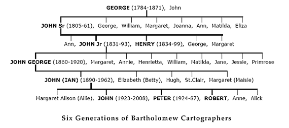
The Bartholomew Mapmakers
The Family behind the company [1]
The family myth was that the Bartholomews were Huguenot refugees. In reality, recent DNA shows they came to Scotland from Southern Scandinavia around the time of the Viking migrations.
One can take an inclusive view that the Bartholomew dynasty started in the 18th century with George.
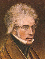
engraver (1784–1871)
Artist's impression

George Bartholomew (1784–1871) should be considered as the father of Bartholomew cartography. In 1797 he was apprenticed to the well-known engraver Daniel Lizars, becoming an independent engraver in 1806, while continuing to work for Lizars. Latterly he worked for his son, John Snr (below), who set up his own business in 1826. This has been regarded as the beginning of the family firm, as George did not actually publish the maps he engraved. George outlived his son by a decade. For a time there were three generations working together – John Snr, his father and two of his sons.
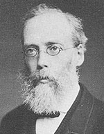
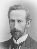
(1805–1861)
John Bartholomew Snr (1805–1861) was a veritable master copper plate engraver. He engraved some fine maps for local firms, such as street maps for Lizars, others for the Encyclopaedia Britannica and for some educational publishers like A & C Black. He was a pioneer, encouraging his son to make contacts abroad and learn from the German school of cartography. The other son in the business, Henry Bartholomew (1834-99), may have engraved the map of Treasure Island for R.L.Stevenson’s bestseller, a project for which John Jnr was commissioned.
John Snr was the ideal person to inaugurate what became one of the most admired cartographic institutions in the world. A man of high standards, as were his successors; he was a superb engraver, engraving becoming the foundation of the firm; lithography would follow later. He also had the vision to recognise the potential for the firm. He was a shy man, holding back from public life.
(1831–1893)
In 1859, shortly before he died, John Snr passed the business on to his son John Bartholomew Jnr (1831–1893), who expanded it significantly with noisy, steam driven ‘flat bed’ lithographic printing presses, in which a huge block of limestone trundled back and forth with a great shudder. The latter part of the nineteenth century was a time of exploration and colonial expansion. Teaching about this expanding world blossomed in all schools, creating a demand for school atlases. This was a very profitable market, with large print numbers and reprints, and many different editions. (The Oxford Press ordered school atlases in about ten different languages for India alone – eg Urdu, Marathi, etc).
Educational reform also created a demand for encyclopaedias – which often had an atlas gazetteer volume. Again the print runs were huge, and profitable. John Snr was an internationalist, and soon the business acquired a world reputation among geographers and cartographers.

pioneered by JB Jnr
John Jnr was creative and saw the potential of the firm to create cartography as a social benefit rather than just a printed product. In the late 1870s he introduced a pioneering system of showing height by changing the colour between contours: delicate greens and browns for plains and foothills, darker browns for high ground, white for mountain tops and blue for water depth (layer colouring). This took time to catch on, but was the basis of all Bartholomew cartography to follow.
He greatly enriched his firm’s tradition and its reputation for accurate, painstaking cartography. Geography, travel and the study of maps were now popular. His main contribution was to negotiate with the Ordnance Survey to let Bartholomews produce two national series of sheet maps, reduced from the O.S. One-inch, one of them to replace the O.S. half-inch scale. These popular scales of a quarter- and a half-inch to the mile contributed significantly to the popularisation of maps and their study. He also saw the potential of maps on specialised themes (eg a map of diseases) which his son, John George (JGB), was to expand. Johns Snr and Jnr worked very hard; the father developed an illness in mid-life. John Jnr loved travel, and after JGB joined the business in 1879, John Jnr spent much time abroad visiting business contacts. In 1885 he made a tour of the USA.
(1860–1920)
John George Bartholomew (1860–1920) succeeded his father in 1888 and built on his rich range of maps and atlases, bringing the firm to its zenith with many innovations, and a series of more academic titles and many distinguished atlases (like The World Atlas of Zoogeography) . He counted many well known figures (academics and writers) as his friends. He completed Bartholomew's Half-Inch Series in 1903 which, with the popularity of cycling, of the motorcycle and then the car, became the firm’s bread and butter for two generations.
His flair was to recognise which titles could become bestsellers, reprinting ten or more times. The print numbers increased (half a million London plans for the 1897 jubilee celebrations; 225,000 timetable maps for the L & NW Railway). But JGB also took on really big projects, some of which, like the Survey Atlases of Scotland (1895) and England (1904) on a half-inch scale, taxed the firm’s resources. His greatest accomplishment was The Times Survey Atlas of the World. Sadly, he did not live to see its publication. His son Ian brought it out soon after his father’s untimely death.
John George inherited his father’s desire to make international contacts. He was a co-founder the Royal Scottish Geographical Society (RSGS) in 1884. He also financed a readership of geography at Edinburgh University. It was his son who saw his dream realised of the establishment of its first chair of geography. His poor health prevented him from pursuing his father’s love of travel. Instead he did this remotely, by summoning the great explorers to come and lecture at the RSGS in Edinburgh. There were still vast unmapped areas of the world, so John George became a virtual explorer.
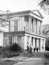
Morningside, Edinburgh
He was reserved and studious; his insistence on accuracy and quality in all his work made him an exacting employer. But John George was a benevolent one, organising recreational activities for his staff and a unique profit-sharing scheme (unheard of at the time). He was ambitious and his life displayed a kind of élan that contributed to the success of his business: as with his renting the extravagant Palladian house of Falcon Hall as the family home and, following its demolition, making its impressive pillared frontage the main feature of his new Geographical Institute on Duncan Street.
In 1910, John George was awarded the royal warrant as Cartographer to George V, and to three further sovereigns, which lapsed in 1962 on the death of his son.
The German school of cartography was pre-eminent, and four generations of Bartholomews widened their knowledge by studying with the German masters. John Jnr studied for two years (1855) with Augustus Petermann. John George’s son Ian studied in Leipzig (1907-8) with Oswald Winkel. His grandson John Christopher carried on the tradition, studying with Eduard Imhof, the great Swiss cartographer, in Berne and Zurich in 1960, and his son John Eric followed in 1977 with Imhof’s pupil, Ernst Spiess.
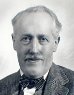
(1890–1962)
John (Ian) Bartholomew (1890–1962) was very creative in his own way; his introduction of modern rotary printing presses, his designs of new map projections; his initiation of the World Series and an important family of atlases were seminal. He brought out the impressive Mid-Century edition of the Times Atlas in five volumes. Acknowledging that this was unwieldy, he subsequently designed a one-volume edition, The Times Comprehensive Atlas, which was not published until after his death.
A shy man, he did not push himself forward. I think he must have found JGB a hard act to follow, but he did extremely well, keeping the name Bartholomew very much in the public’s awareness. He kept up his father’s association with the RSGS, first as Secretary, then as President. He and his father were justly honoured, both with LLDs from Edinburgh University, JGB (and his son) with the royal warrant, and Ian with the CBE.
On his father’s death, Ian followed John George as Secretary of the RSGS, later to become its President (1950-1954). John Christopher joined the council in 1951, later becoming President (1987–1993). The family visitor’s book has many of the famous names of world exploration of those days. That three generations of Bartholomews have been at the centre of the RSGS for some 115 years since its inception is quite exceptional for any learned society.
The changeover to the next generation was not so smooth. There was no one in the family who was able to continue the level of cartographic innovation demonstrated by the previous three Johns. John Christopher Bartholomew (1923-2008) had started as a cartographer in 1949, after an initial apprenticeship while he completed his geography degree. He became cartographic director in 1953. His brother, Robert Bartholomew (1927–2017) also joined the firm in 1953 after a printing course, an apprenticeship, and spending some time in London with the firm’s wholesalers. He became production director in 1955.
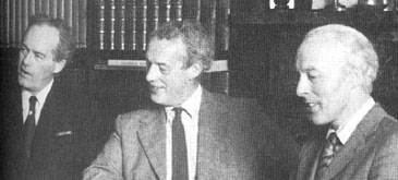
In 1956, Ian wanted his son Peter Hugh Bartholomew (1924–1987) to return to Edinburgh to take over management of the firm. Peter responded without rancour; his qualities included a sense of duty and responsibility. John and Robbie were in place as cartographic and printing directors. Robbie learned well from Willie Dickson, production manager, who served the company loyally for 53 years until his retirement in 1967, and Robbie succeeded him as head of production.
Peter was a very able managing director, working hard to learn this complex business, his background having been accountancy and running one of Garfield Weston’s bakeries. His brothers by now were well-experienced in their own areas of the business, and his skill was the ability sensitively to get the managers to work as a team. In 1961 he appointed David Cunningham as financial director. But in the late 1960s Peter had one heart attack after the other, and realised he had to slow down. So, in 1969 he headhunted David Ross Stewart, who had had broad managerial experience, to be managing director, and Michael Chittleburgh in 1972 as marketing director. Bartholomews had not had a marketing department, but now there were ten national sales reps also appointed.
In the 1960s (and into the 1970s) there was more emphasis on contracted printing work, like The Times Moon Atlas (1969), The Times Atlas of World History (1978) and the huge Reader’s Digest series of some 20 national atlases (1963+), where the cartography was not done in-house. This kept Robbie very busy. In 1972, the very successful Half-inch Series was replaced by the National Series at larger scale of 1:100,000 – actually the Half-inch enlarged, which made for greater legibility, with new place names photoset instead of engraved, and the same sheet numbers. The scale change was required under the British government’s policy of decimalisation (just as the Ordnance Survey enlarged their One-inch series to 1:50,000).
John Christopher was a fastidious and knowledgeable editor and a skilled cartographer. He continued his father’s and grandfather’s contribution to geographical and cartographic conferences and was highly respected in international circles. Like his forebears, he was President of to the RSGS. He lectured widely (even in French). In the years before he died, he nearly completed the mammoth task with the National Library of Scotland collating the Bartholomew Archive.
There were tensions on the board in the 1970s. Peter’s first stroke, and the weakening position of the firm in the market, made it inevitable that the family would have to give up control of the business.
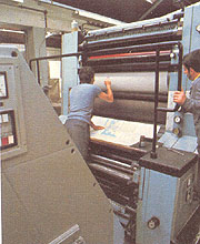
Bartholomew's (ca.1975)
When Peter announced his decision to sell to Reader’s Digest (RD), there were some dissenting voices amongst the shareholders. Bartholomews had by then a very modern plant, with equipment and goodwill worth millions. Unfortunately the firm had lost its prominence as Britain’s premier cartographer, and was in a weak position financially.
The partnership with Reader's Digest made sense at the time with the opportunity of extending the global reach of Bartholomew's map, atlas and book products. At that time, the company was already producing most of the maps for the Reader's Digest Atlas with foreign-language editions for sixteen countries and sales in excess of seven and a half million copies.
In turn, Reader's Digest sold the company to News International in 1985 (the UK subsidiary of News Corp which was controlled by Rupert Murdoch).
Two of the 7th generation (John Eric and Alistair) pursued careers in cartography. Several did spells at Bartholomews. Geography was not a university subject until the 1900s; four generations were students of geology: John George, John [Ian], Alick, Iain, David & Patrick; and three of geography John [Ian], John Christopher, Alick, John Eric & Jane.
The print and digital mapping legacy continues to thrive under the name Collins Bartholomew. This division of Harper Collins is currently based in Robroyston, Glasgow, Scotland.
[1] Abridged & adapted from 'Postscript to Bartholomew 150 Years', by Alick N. Bartholomew (2008)