
Treasure Island Map
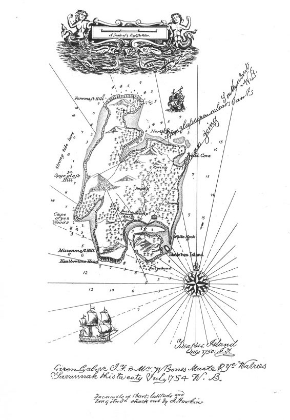
John Bartholomew junior is said to have been commissioned to engrave the map of Treasure Island for the first edition of Robert Louis Stevenson's bestseller in 1883.
The first map was allegedly lost en route to Cassell, the London publisher. RLS ordered a replacement engraving which is the one shown above, published 1895. [1]
John's brother, Henry Bartholomew (1834-99), may have been the one who actually crafted it, though this is uncertain.
Under Robert Louis Stevenson's instructions, John Bartholomew was commissioned to supply the frontispiece to the first edition of the book. How many times it has been reproduced is hard to estimate. Treasure Island would not be Treasure Island without the evocative island plan and its 'Spy Glass Hill' and 'Cape of Ye Woods', delineated by 'Billy Bones', with latitude and longitude 'struck out by J. Hawkins'.
Running a hand over the worn old copper plate in the Bartholomew Archives, one hears an echo from childhood of the tap of Blind Pew's stick and the parrot's cry: 'Pieces of Eight! Pieces of Eight!'. [2]
[1] From Bartholomew 150 Years, Leslie Gardiner (1976)
[2] Treasure Island, Edinburgh Edition of 1895.